Salmon Bay K-8’s Traffic Circulation Plan
There are many modes of transportation to get to school each morning. To learn more about SPS transportation guidelines and eligibility, please click here.
In 2025, the FOSB Traffic Safety Committee worked with Salmon Bay and the Seattle Department of Transportation (SDOT) to roll out a circulation plan for drop-off and pick-up.
Please consider how your family’s drop-off and pick-up routines can work with our school’s plan:
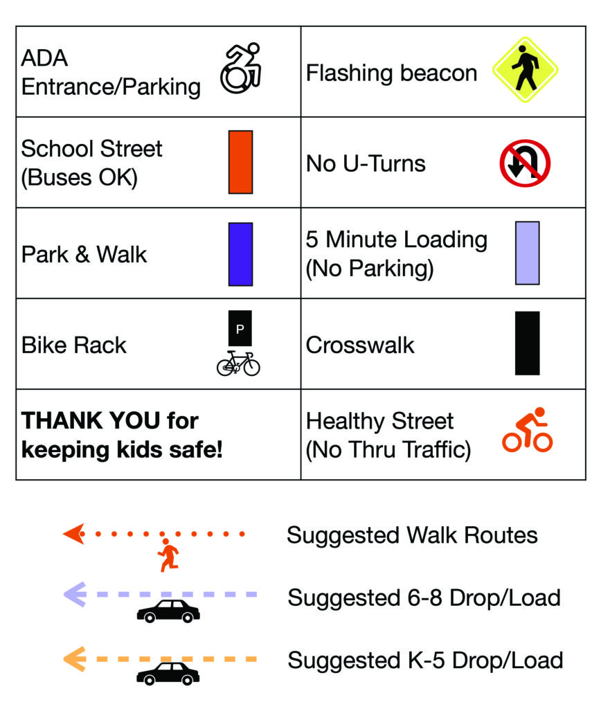
- Drop/load by car east, with new suggested K-5 / 6-8 areas
- Park & Walk west, with new suggested parking zones
- School Street on 19th alongside buses (NO thru traffic)
- No Parking on the west side of 18th, per “Load Only” signs
Help us keep kids safe! Follow these rules when you travel to and from school:
- DO cross only at crosswalks and corners
- DO find a legal parking space and walk with your child
- DO stay with your car at all times in the drop-off/pick-up areas
- DO NOT make U-turns near school
- DO NOT park on 18th in the drop-off/pick-up areas
- DO NOT drive on 19th in the School Street/School Bus area
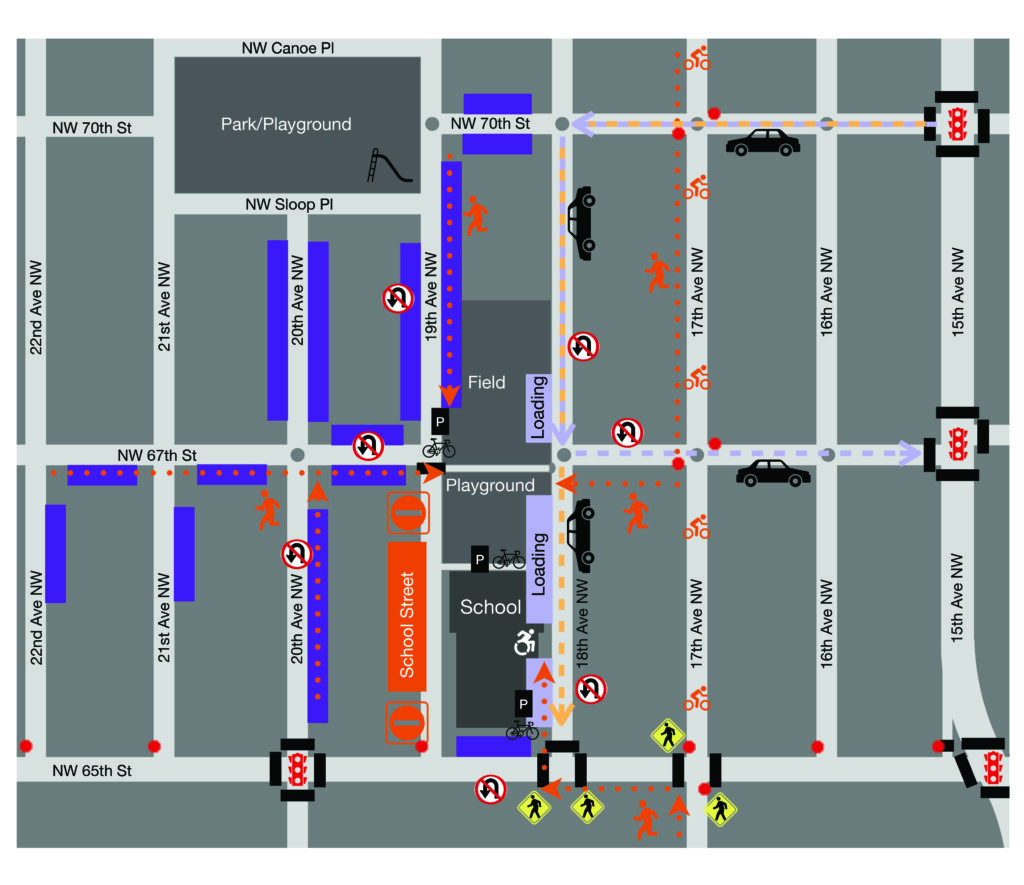
Salmon Bay K-8 Circulation Map
Parking Information
Salmon Bay does not have a parking lot. The west side of 18th Ave NW is for 5 minute loading and unloading only. This is in effect 7 AM – 4 PM on school days. There are also two accessible (ADA permit required) parking spots on 18th. The east side of 19th Ave NW is for school buses only, and this block is also a School Street. School Streets are open for school buses and people walking and biking and closed to through traffic (including school drop-off and pick-up). This is in effect 7 AM – 5 PM on school days.
We encourage families to walk, roll, or bike with your child to school. If you must drive, try parking a block or two away and finishing the trip on foot, aka “Park & Walk.” Many school community members prefer street parking to the west of the school, as it is further from 15th (a busy arterial) and Ballard High (where many students use neighborhood street parking).
We recognize teachers and staff need to park near the school. If you drive and park, we suggest you use legal street parking a few blocks away, or on the north side of 65th between 18th and 19th. If you have items to unload from your car, please do use the 18th loading zone, and then move your car to a legal street parking space.
Do not park or stop to load or unload in an intersection. Parking is never allowed within 5 feet of a driveway, 15 feet of a fire hydrant, 20 feet of a crosswalk or intersection, or 30 feet of a stop or yield sign. Parking is also not allowed in loading zones, alleys, on sidewalks or planting strips, in tow-away zones, bus zones, or no-parking zones.
More Information
About the Circulation Map
School traffic circulation maps are visual representations that outline the planned flow of vehicular and pedestrian traffic around a school campus during drop-off, pick-up, and other times when school-related traffic is high. These maps are designed to help parents, students, staff, and neighbors understand the most efficient and safe routes for entering, exiting, and navigating near the school premises.
These maps are distributed to families, staff, and neighbors to provide guidance on navigating the school area safely and efficiently during peak traffic times. They aim to minimize congestion, reduce the risk of crashes, and create a smoother traffic flow around the school.
Our circulation map also includes suggested Park & Walk locations. These are areas near the school where families who drive can park, or older students can be dropped off and walk the remainder of the distance to school. This reduces car traffic in front of the school and allows you to skip waiting in the drop-off line, while students start the day with healthy physical activity, arriving at school more ready to learn.
About the FOSB Traffic Safety Committee
Our committee formed in late 2024 to begin developing a new Circulation Plan and Map for Salmon Bay K-8. Each of the new elements 1-4 were chosen with safety, accessibility, and community building in mind, after extensive outreach to families, neighbors, staff, and SDOT.
The “Why” Behind Each Element of the Circulation Plan
1. Drop/load by car east, with new suggested K-5 / 6-8 areas
This element gives families who drive and plan to stay with the vehicle designated areas for dropping off and picking up their students.
We suggest all families using this mode access the neighborhood via the traffic light at 15th/70th. We suggest older students use the loading zones north of 67th so drivers may exit the area via the traffic light at 15th/67th, and we suggest younger students use the loading zones south of 67th to minimize street crossings.
2. Park & Walk west, with suggested parking zones
This element gives families who drive and plan to exit the vehicle suggested areas for parking a few blocks away and walking to school.
We encourage families who drive to choose Park & Walk whenever possible. Street parking is more abundant to the west since it is further from Ballard High, and accessing Salmon Bay on foot from the west will be safer than ever with the new School Street on 19th.
Please note that when we say “west,” we do not mean “immediately west on the block of 19th that is a School Street. Instead, refer to the “Park & Walk” suggested areas on the Circulation Map.
3. School Street on 19th alongside buses (NO thru traffic)
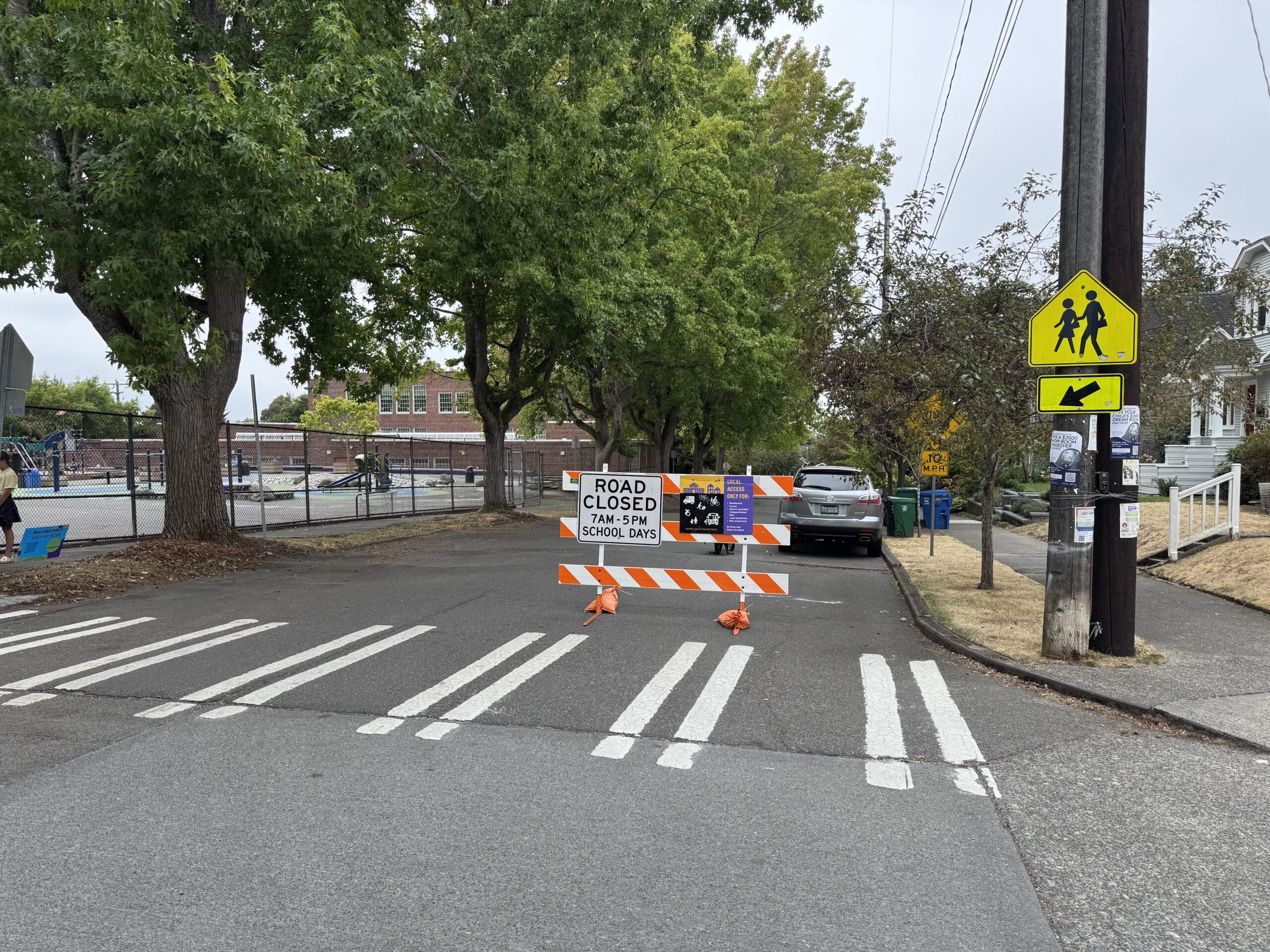
School Street on West Side of Salmon Bay Elementary (19th Ave, between 65th & 67th)
This SDOT program element enhances safety for families who walk (including Park & Walk), bike, and ride the school bus. It directly addresses one of our community’s top problem areas: the uncontrolled intersection and crosswalk at 19th/67th.
School Streets are open for school buses and people walking and biking and closed to through traffic (including school drop-off and pick-up). School Streets disperse the car traffic around a school so walking and biking to school is more welcoming with cleaner air and more comfortable crossings.
There is still plenty of room for school buses to access the bus zone and for neighbors to access their homes. Our School Street is in effect from 7am–5pm on school days.
4. No Parking on the west side of 18th (5 minute loading zone)
This element increases safety for families who walk, bike, and drop/load by car.
It addresses another of our community’s top problem areas: double parking on 18th and congestion at 18th/65th. We ask that drivers who need to stop their vehicle for more than 5 minutes, or exit their vehicle for any length of time, please find a different place to park.
This includes a portion of 18th north of 67th! The loading zone extends north along the west side of 18th to the first driveway along the field.
Frequently Asked Questions
Where am I supposed to park?
Please see the “Parking Information” section above.
What do the curb colors mean?
The FOSB Traffic Safety Committee recently painted some curbs near the school yellow and red to remind drivers about loading zones and intersections, respectively. All the loading zones on 18th (yellow) are 5 minute load/unload only 7AM – 4PM school days. It is never legal or safe to stop to drop off or pick up in an intersection (red).
How does a School Street work, and why?
School Streets are an SDOT program, and there are over 18 citywide. School Streets are open for school buses and people walking and biking and closed to through traffic (including school drop-off and pick-up). School Streets disperse the car traffic around a school so walking and biking to school is more welcoming with cleaner air and more comfortable crossings.
There is still plenty of room for school buses to access the bus zone and for neighbors to access their homes. Because our School Street uses temporary signage and is not permanently installed in concrete, this one block of 19th is closed to pass through traffic 7AM – 5PM on school days. Over the summer, SDOT stores the signs for us, and then they return for the next school year. For more information, please see seattle.gov/schoolstreets.
Why is the School Street on 19th and not one of the other streets near Salmon Bay?
We considered several options, and concluded that designating one block of 19th as a School Street would best meet our community’s safety needs while minimizing inconveniences to neighbors. 65th is classified as an arterial and cannot be designated a School Street. In Fall 2024, there was a brief School Street pilot on 18th between 65th and 67th. However, it was not part of a well-communicated circulation plan. Families who drive did not have a clear route to access the school, and unsafe driver behaviors (U-turns, backing up, illegal parking, etc.) increased. It was canceled after about one week.
Thankfully, 19th between 65th and 67th is a different story. This is already the district-designated School Bus Zone. The road itself is very rough and bumpy due to tree roots. Many families have raised safety concerns about the uncontrolled intersection and crosswalk at 19th/67th. We realized that if we designated this block of 19th (between 65th and 67th) a School Street, we could alleviate this problem — so departing vehicles have to go either north on 19th or west on 67th, leaving the crosswalk traffic-free — and also enhance safety for school bus riders. Nearby Whittier Elementary also has a School Street co-located with their School Bus Zone.
How am I supposed to drop off students by car?
We encourage you to Park & Walk a few blocks from the school and walk with your child to school. This can be a wonderful community building opportunity!
If you don’t plan to park, the Circulation Map shows suggested driving routes for dropping off and picking up students in grades 6-8 and grades K-5.
To drop students off without parking, we suggest you drive into the neighborhood via the traffic light at 15th/70th and turn left (south) on 18th. Drop older students on the west side of 18th north of 67th, and then turn left (east) to the traffic light at 15th/67th. Drop younger students on the west side of 18th south of 67th (near the Panther Passage entrance), and then drive straight (south) to 65th.
How am I supposed to pick up students by car?
We encourage you to Park & Walk a few blocks from the school and walk with your child back to your car. This can be a wonderful community building opportunity!
If you don’t plan to park, the Circulation Map shows suggested driving routes for dropping off and picking up students in grades 6-8 and grades K-5. Make a plan with your child so they know when and where to find you!
To pick students up without parking, we suggest you drive into the neighborhood via the traffic light at 15th/70th and turn left (south) on 18th. Ask older students to meet you on the west side of 18th north of 67th, and then turn left (east) to the traffic light at 15th/67th. Ask younger students to meet you on the west side of 18th south of 67th (near the Panther Passage entrance), and then drive straight (south) to 65th.
How does the Circulation Plan affect school bus riders?
The routine for students who ride the school bus has not changed. Bus riders will now enjoy increased safety when they arrive and depart school, because 19th between 65th and 67th is closed to pass-through traffic on school days from 7AM – 5PM as a School Street.
How does the Circulation Plan affect families who walk or bike to school?
These modes are highly encouraged! The Circulation Map shows suggested walking routes that include intersections with safety features such as flashing beacons, stop signs, and marked crosswalks. Salmon Bay has three convenient bike racks: one at the SE corner of the school near 18th/65th, one at the NW corner of the school near 19th/67th, and one in the Panther Passage. Please walk your bike in the Panther Passage, and note that both gates are locked during the school day.
Salmon Bay is located near the 17th Healthy Street, an ideal walking and biking route. Healthy Streets are designated by SDOT as closed to pass through traffic, but open to people walking, rolling, biking, and playing. For more information, see tinyurl.com/sdothealthystreets.
How does ADA access work?
The routine for ADA (Americans with Disabilities Act) access is the same. There are still two designated ADA parking spots on the west side of 18th near the main school entrance.
Families who need to use this space will enjoy increased safety since the rest of this portion of 18th is a loading zone (no parking).
Does the Circulation Plan affect field trips, after school programs, or weekends/holidays?
Not typically, no. School Circulation Plans communicate how to access a school during drop-off, pick-up, and other times when school-related traffic is high. They are designed to help parents, students, staff, and neighbors understand the most efficient and safe routes for entering, exiting, and navigating near the school premises.
Our Circulation Plan is most essential immediately before and after school: 8:30–9:05am and 3:15–3:50pm (2:00–2:35pm on Wednesdays) during the school year. Per SDOT, the School Street is in effect from 7AM – 5PM on school days. Seattle parking regulations always apply.
We have spoken with the staff at the Salmon Bay Boys & Girls Club (Coho) after school program to share our circulation plan with them. The majority of Coho pick-ups happen between 5–6pm, and are not affected by the School Street. If you need to pick your child up before 5pm by car, we suggest you park on 19th north of 67th.
Why don’t you hire a crossing guard?
This is one of the most common suggestions we get! Many families who have been at Salmon Bay for years fondly remember the 20 year tenure of our crossing guard Des, who retired in October 2022.
Unfortunately, one crossing guard cannot singlehandedly address the safety concerns on streets and at intersections all around the school. We need clear directions that minimize unsafe driver behaviors for people arriving at school by all modes of transportation, and this gap is what our Circulation Plan aims to fill.
That said, we would love to hire a crossing guard! Learn more and apply at seattleschools.org/departments/transportation/jobs.
Does Salmon Bay have a bad history of car crashes?
Salmon Bay has a long history of challenges with traffic safety. In 2001, a student was struck by a car in a crosswalk at 18th/65th, prompting her father to take a job as a crossing guard. In 2013, that crossing guard was struck by a car in the same location. Circa 2016, flashing beacons were installed by SDOT to improve pedestrian safety at 18th/65th.
In May 2023, a parent and neighbor wrote in the Salmon Bay Newsletter that she had witnessed 3 crashes along 67th on the west side of the school in 5 months. The FOSB Traffic Safety Committee is aware of at least 9 crashes involving a car near the school in the 2023–2024 school year, and at least 60 near-misses in the same time frame.
We hope you agree this state of affairs is unacceptable! You can help keep kids safe by following our school’s Traffic Circulation Plan.
How did you develop the Circulation Plan?
Once we decided a change was needed, we focused our efforts on consulting with experts (like folks at SDOT) and listening to the community’s needs. We started going to FOSB meetings and getting feedback from other engaged families and Principal Dixon. We realized we could form a new Traffic Safety Committee, so we did! Each committee member has unique ideas and perspectives, but we are committed to working together to improve safety, even if the end result doesn’t look exactly like any one person’s vision.
We have attended FOSB events, developed a relationship with the Safe Routes to School team at SDOT, learned from Principal Dixon and staff about past approaches, and reached out to families and the community with surveys. Our first survey, which was open from Nov-Dec 2024, captured input from 167 families representing 215 students. Our second survey, which ran from Apr-Jun 2025, during the initial rollout period, had fewer responses but helped us make targeted changes for the 2025-26 school year.
Oh, and once we sat at Mabel Coffee with a giant white board map and passionately discussed minutiae of traffic engineering and how people use public streets. We are a small group of volunteers and we are counting on your help to keep our school safe and welcoming!
How can I get in touch with you?
We value your input! To learn more, we encourage you to come to a monthly FOSB board meeting and chat with us. You can also reach out directly to the FOSB Traffic Safety Committee co-chairs, Meredith Rawls and Mike Bigelow, with any urgent questions or concerns: meredith.rawls@gmail.com and mbigelow@gmail.com.
Are you planning any other changes in the near future?
Yes, we hope so! Our School Street shows SDOT that Salmon Bay is serious about traffic safety, this will help fast track the area surrounding our school for more permanent infrastructure upgrades. These are likely to include all-way stops at 18th/67th and 19th/67th, painted crosswalks at 18th/67th, and possibly speed humps along 18th and 19th. We are also interested in advocating for SDOT to do a traffic study on 65th between 15th and 20th to see if more traffic calming elements are warranted.